Some of my friends, family and colleagues ask me why a plane can be lost over the ocean without knowing its last position, as the Malaysia Airlines MH370 flight disaster. Looking for documentation, I’ve ran across with this great video by NATS, the British Air Navigation Service Provider company, that shows how the commercial flights are routed over the Atlantic Ocean without radar, one of the main problems that explains, to the date, how we do not know an aircraft position in real time over the ocean.
This video is very illustrative about how a flight is managed in a no radar environment scenario based in the Shanwick Oceanic Control Area (OCA) and neighborhood areas, tactical route planning, what systems support the process, air space capacity optimization, safety procedures, risks management, emergency what-if scenarios, ATC/ANSPs coordination, pilot/ATC communication, etc.
Credit: NATS
STARTING THE ENGINES
Before introducing the video, and for having an introductory vision of the North Atlantic Air Traffic, do not miss the following video, also produced by NATS.
TARGETING RISKS WITHIN THE SHANWICK OCA. VIDEO SECTIONS
The video is divided in the main following sections:
- A Westbound Flight, for showcasing the procedures in a normal flight from Dublin to Boston. How the pilots uses the ACARS system and the alternative HF/VHF radio communications.
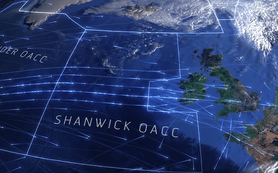
- The South-East Corner, a critical air navigation area that implies the southwest of Britain (Shanwick OCA), west coast of France (Brest OCA) and the Spanish atlantic area (Madrid OCA). This in an area heavily crossed by the flights from/to Spain-Britain, Europe-Latin America, Europe-Central America, Europe-NorthAmerica, and flyby flights from the East of Europe to America, as the Middle-East flghts.
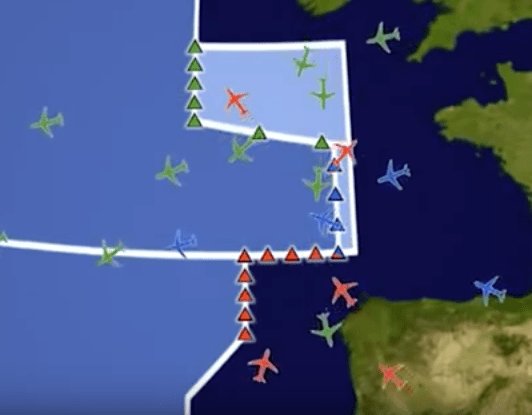
The South-East Corner. Shanwick OCA, Brest OCA and Madrid OCA. Copyright: NATS and SPA
- When things go wrong: any conflict or deviation in vertical, lateral and longitudinal elements of the air space and waypoints, and any incidence regarding to separation minima between aircrafts. The conflicts with other traffics.
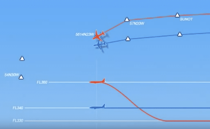
Air navigation deviations. Copyright: NATS and SPA
ENJOY THE NATS VIDEO
It takes 70 minutes, so relax and enjoy it.
FLIGHTS OVERTAKINGS AND CROSSINGS
For illustrating best the benefits of this air navigation holistic system, here you have three videos with some of the situations explained in the NATS video.
SEVERAL OVERTAKINGS AND CROSSINGS FROM THE COCKPIT
OVERTAKING AN AIR CANADA FLIGHT 1000 FEET ABOVE
QANTAS B747 AND A380 FLYING IN PARALEL, DIFFERENT ALTITUDE
NORTH ATLANTIC OPERATIONS AND AIRSPACE MANUAL
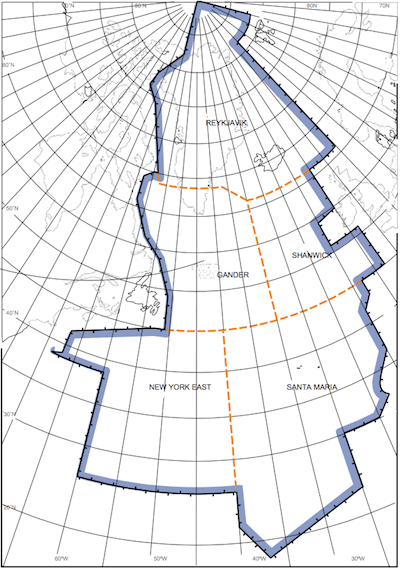
Minimum Navigation Performance Specification (MNPS) Airspace. Credit: ICAO
In the video, they named an interesting document, published by ICAO, the North Atlantic Operations and Airspace Manual that illustrates and describes the general procedures, requirements, the oceanic clearances, communication procedures, flight operation and navigation procedures, contingencies, etc. Is a guide for the operation in this air navigation area.
You can download it from the following link. ICAO NAT Doc 007
ACARS
Aircraft Communications Addressing and Reporting System (ACARS) is a system and protocol designed by ARINC (now a Rockwell Collins company) in 1978 that transmit data between aircraft and ground stations. ACARS messages may be sent using a choice of communication methods, such as VHF or HF, either direct to ground or via satellite.
Aircraft-Ground data communication Credit: http://www.technologyvista.in
ACARS messages may be of three types based upon their content:
- Air Traffic Control (ATC), as shown in the NATS video.
- Aeronautical Operational Control (AOC)
- Airline Administrative Control (AAC)
- Free Text messaging is also possible.
This is an example of a message sent to a pilot from the ATC, this communication is also known as Controller-Pilot Data-Link Communications (CPDLC):
ABC123 CROSS 50N040W AT OR BEFORE 1428
AFTER PASSING 50N040W MAINTAIN MACH 082
The meaning is, “Flight ABC123 is to adjust its speed to ensure that the flight will reach the coordinates 50N 040W no later than 1428 UTC. After passing coordinates 50N 040W, the flight is to maintain speed Mach 0.82.
The next picture shows the point of view of an ATC controller’s workstation, in this case from the Maastricht Upper Area Control (MUAC) managing an Air Europa’s flight (AEA1098)
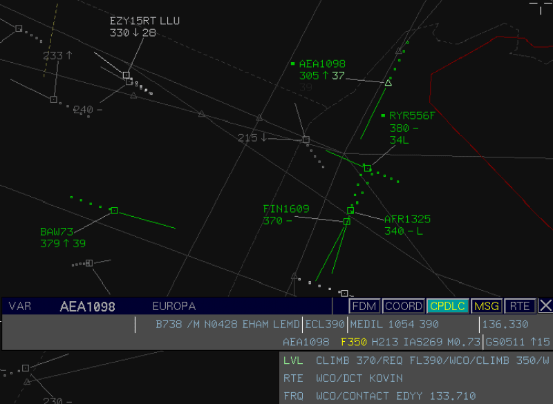
Example of ATC screen when using CPDLC at MUAC. Credit: Eurocontrol
Here you can see the pilot’s perspective:
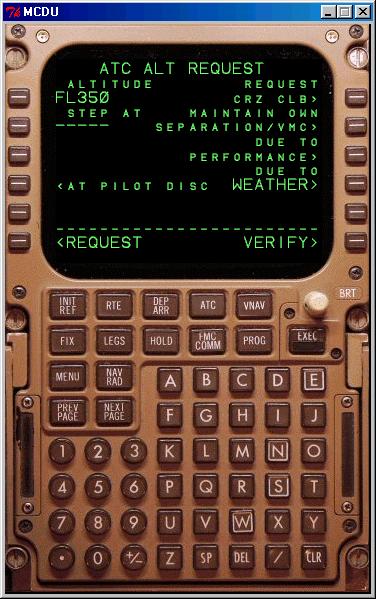
Interface Pilot-ACARS System integrated in the FMS. Credit: www.hoppie.nl
ATC messages include aircraft requests for clearances and ATC issue of clearances and instructions to aircraft. They are often used to deliver Pre-Departure, Datalink ATIS and en route Oceanic Clearances. However, whilst the ACARS system is currently fulfilling a significant ‘niche’ role in ATC communications, it is not seen as a suitable system for the more widespread ATC use of datalink which is expected to come in the future.
AOC and AAC messages are used for communications between an aircraft and its base. These messages may be of standard form or as defined by users, but all must then meet at least the guidelines of ARINC Standard 618. Any message content is possible including such examples as:
- upload to the aircraft of final load and trim sheets;
- upload of weather or NOTAM information;
- download from the aircraft of status, position, eta, and any diversion;
- download of technical performance data including automatically triggered exceedance or abnormal aircraft system status information, and
- ‘housekeeping’ information such as catering uplift requirements, special passenger advice and ETA.
Here you have a couple of brief videos with an ACARS demo onboard.
A Datalink Service Provider (DSP) is responsible for the movement of messages via radio link, usually to/from its own ground routing system. ACARS messages are transmitted using one of three possible data link methods:
- VHF or VDL (VHF Data Link) which is line-of-sight limited
- SATCOM which is not available in polar regions
- HF or HFDL (HF Data Link) which has been added especially for polar region communications
The main service providers are SITA and ARINC, here you can see their architecture solutions:
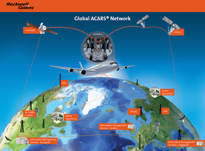
Global ACARS Network by ARINC. Credit: www.arinc.com
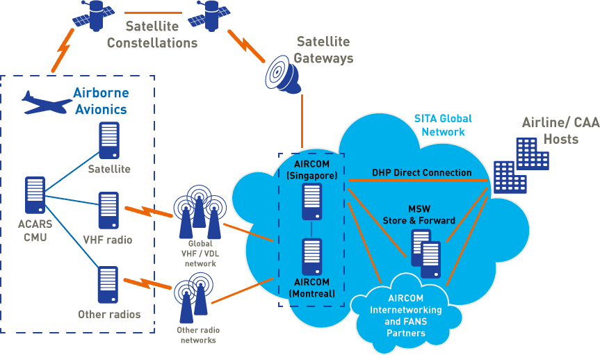
SITA AIRCOM ACARS Services. Credit: www.sita.aero
AIR NAVIGATION BOOKS AND A GREAT WEBSITE
I’m reading a couple of Air Navigations books, and I have to say that this is an amazing aviation field that should be more promoted and known. These are the books I’m reading (referral inks):
[amazon_link id=”0071477209″ target=”_blank” container=”” container_class=”” ]The Aviator’s Guide to Navigation[/amazon_link]
[amazon_link id=”8415452810″ target=”_blank” container=”” container_class=”” ]Introducción al sistema de navegación aérea[/amazon_link]
The International Virtual Aviation Organization (IVAO) website is a must for any newcomer in this field, it is a great Air Traffic simulation platform and community. A perfect first step for introducing in this unknown aviation world. You can be a controller or a pilot using its ATC software client and flight simulators plug-ins for FSX, XPlane an Prepar3D software.

IVAO website. www.ivao.aero
BONUS TRACK
Air Navigation is one of the less known activities in aviation, but with the NATS illustrative videos the things are changing, among others, as the youtube channels of Eurocontrol (Eurocontrol TV) or twitter accounts of the Spanish controllers @controladores and Eurocontrol @eurocontrol. Do you know great ATC twitter accounts to follow, tell us at @aeriaablog
As a bonus track of this post, another video of NATS (with FlightAware data) with the Air Traffic over USA.
POST UPDATE [JANUARY 2016]
I’ve recently found this interesting video by NavCanada.
Improving Air Traffic Management in the North Atlantic from NAV CANADA on Vimeo.
FOR MORE INFO
NATS: www.nats.aero
Eurocontrol: www.eurocontrol.int
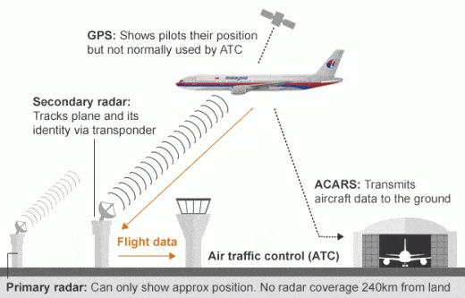
MH370 info. http://www.technologyvista.in/pin/missing-malaysian-jetliner-facts-figures-possibilities/
Rockwell Collins ARINC ACARS: nice interactive infographic.
SITA AIRCOM ACARS: http://www.sita.aero/solutions-and-services/products/aircom-acars-services
Questions about ACARS: http://aviation.stackexchange.com/questions/2278/what-data-does-acars-send-back-to-base-can-it-be-used-to-track-a-plane
FOLLOW US
- Twitter. @aeriaablog
- Facebook. aeriaA in Facebook
- LinkedIn. aeriaA page in LinkedIn
- Airport Tech Group in LinkedIn
- Personal page in LinkedIn
- Youtube Channel
SOURCES AND BIBLIOGRAPHY
About ACARS: Skybrary.aero & Eurocontrol
- http://www.skybrary.aero/index.php/Aircraft_Communications,_Addressing_and_Reporting_System
- www.eurocontrol.int
About Datalink message: ICAO NAT Doc 007
NATS video: Trackwise. Targeting Risks within the Shanwick OCA. https://www.youtube.com/watch?v=EJTjwW5ZYas